IUCN/SSC Otter Specialist Group Bulletin
|
©IUCN/SCC Otter Specialist Group Volume 29 Issue 1 Pages 1 - 67 (January 2012) Citation: Schmidt, G., Dohet, A., l’Hoste, L., Boscher, A., Cauchie, H.-M., Plon, J., Nederlandt, N., Ghyselinck, H., Plattes, S., Rabold, E., Mousel, A., Casagranda, B., Thommes, P., Krippel, Y., Scheer, A., Glesener, R., Molitor, M., Schiltz, C., Hoffmann, L. and Leclercq, C. (2012). Restoration of the Otter Habitats in Luxembourg and Belgium: 5-Year Actions in Favour of the Eurasian Otter (Lutra lutra). IUCN Otter Spec. Group Bull. 29 (1): 46 - 61 Restoration of the Otter Habitats in Luxembourg and Belgium: 5-Year Actions in Favour of the Eurasian Otter (Lutra lutra) Gerard Schmidt1, Alain Dohet1, Lionel L’hoste1, Aurore Boscher1, Henry-Michel Cauchie1, Jonathan Plon2, Nicolas Nederlandt2, Helene Ghyselinck2, Sven Plattes3, Eva Rabold3, Annick Mousel3, Beatrice Casagranda3, Patrick Thommes5, Yves Krippel5, Anne Scheer5, Bob Glesener5, Mireille Molitor6, Claude Schiltz6, Lucien Hoffmann1, Christine Leclercq7
1Centre de Recherche Public – Gabriel Lippmann, EVA-Département Environnement et Agro-biotechnologies, rue du Brill, 41, L-4422 Belvaux. Email: schmidt@lippmann.lu |
| (Received 23rd January 2012, accepted 21th February 2012) |
| Abstract:
In 2005, 7 partners including 5 Nature Parks (Haute-Sûre, Haute-Sûre Forêt d’Anlier, Our, Hautes Fagnes-Eifel, Two Ourthes), the Hëllef fir d´Natur foundation and the Centre de Recherche Public (Gabriel Lippmann) proposed a LIFE-Nature Project to preserve and restore the habitats of the last otters in Luxembourg and Belgium. This wide and cross-border project aimed to improve the otter’s habitats and try to build or rebuild corridors between the two important otter populations located in France and Germany in order to facilitate the migration of the species and to contribute to re-establish stable otter populations in our countries. To reach these objectives, the following actions were defined: (1) improvement of the natural fish productivity (by the restoration of 6 spawning grounds and the removal of 21 obstacles for fish migration), (2) decrease the impacts related to the presence of cattle alongside rivers (installation of 262 drinking troughs, 61 km of fences, 23 footbridges), (3) promotion of native tree species by the early cutting of spruce forests in floodplains (150 ha), (4) exploitation of the woods while respecting watercourses, (5) stimulation of connections between catchment’s areas by planting the riverbanks with native trees and shrubs (23 km) and the digging of ponds (178), (6) installation of secure passageways under bridges for the otter but also for small mammals (the management of 9 otter passages), (7) creation of nature reserves (105 ha) and otter havens (31) and finally (8) management of invasive plants (189 ha) in the Natura 2000 areas. Public awareness was also an important element of the project with the production of a travelling exhibition and an educational file. Moreover, a network of otter observers composed of volunteers was set up to try to find footprints and spraints in the study area between 2007 and 2010. |
| Keywords: restoration of habitats; public awareness; LIFE-Nature project; Eurasian otter |
| Française | Español |
INTRODUCTION
The Eurasian otter (Lutra lutra L.) is an endangered mammal in Western Europe in other regions as well as Luxembourg and the South-east of Belgium (Walloon Region). Since the beginning of the 1990s, otter populations in France, Germany, England, and other European countries have recolonized a part of the previous distribution area from which it had disappeared during the first half of the twentieth century (Bouchardy, 2001). This is partly a consequence of its protected status by the Berne Convention (1982). In the process of their recolonization, otters mostly used large rivers as migration corridors. For this reason, it appears very important to improve the otter habitat quality in order to allow its dispersal without reintroduction programme.
Until the 1990’s and even later, the otter was considered as very rare in Luxembourg and in the Walloon Region (Reuther et al., 2004) (Fig. 1). Only a few individuals were present along the Sûre and the Our Rivers, the two Ourthes Rivers, and the Semois River. These individuals seemed to lead an erratic life and were not likely to encounter each other (Groupe Loutre Luxembourgeois, 1994).
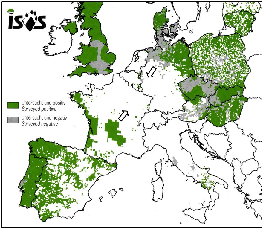 |
| Figure 1. Distribution map of the Eurasian otter referring to the ISOS (Information System for Otter Surveys) databank system (UTM grid 10 km, period 1999-2003) (Reuther et al., 2004). (click for larger version) |
In 1994, the Otter Group in Luxembourg assessed the quality of river habitats for the otter. The results of this study demonstrated that only 40% of the rivers in Luxembourg were suitable for otter populations (Groupe Loutre Luxembourg, 1997). Furthermore, contamination levels of PCBs in fish, an important food resource for the otter, were considered as critical (more than 150 ng PCB/ng fresh body weight) in numerous rivers according to the critical threshold level defined by Leonards et al. (1994). Therefore, all these habitats were considered as potential habitats with risks. In order to improve the situation, some actions were undertaken along the Upper Sûre River to improve the otter habitat and indirectly the water quality: planting of indigenous trees (willows and alders) along riverbanks and setting up of “otter havens” conventions to involve private owners in the protection of natural structures of the river and to avoid human disturbance.
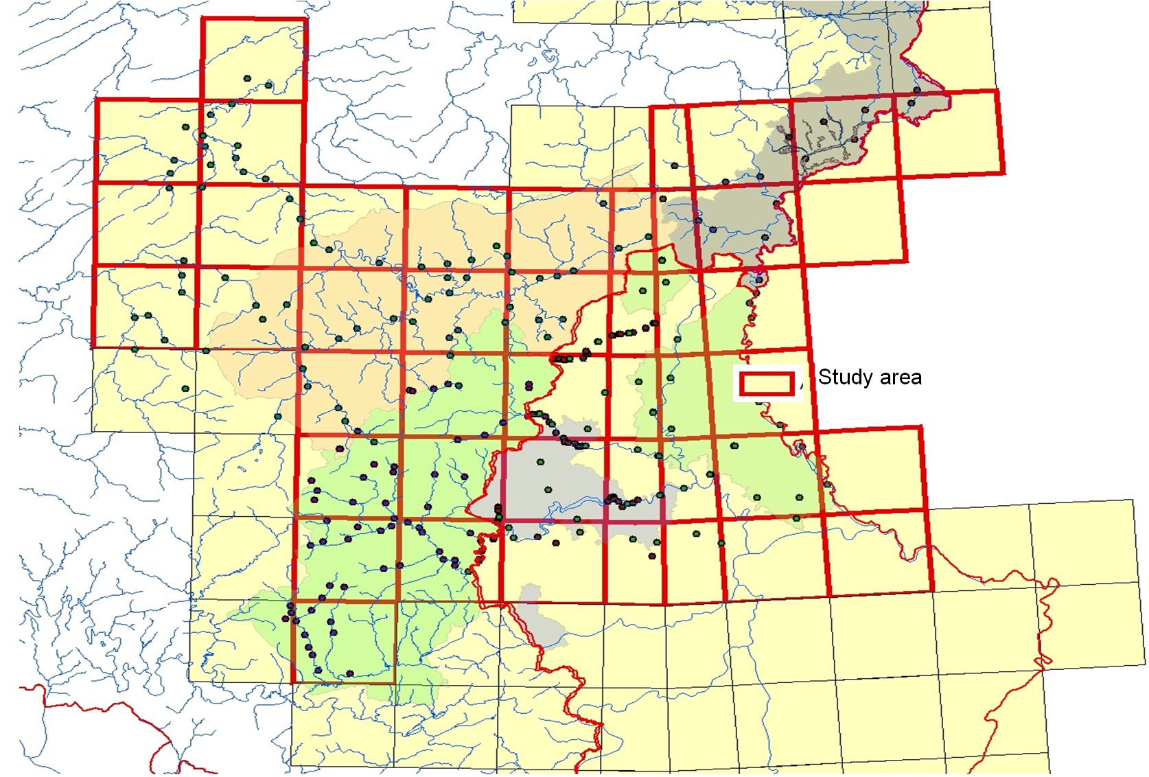
Ten years later, 7 partners (3 of Belgium and 4 of Luxembourg) submitted a LIFE-Nature project to restore otter habitats in the North of Luxembourg and the Southeast of the Walloon Region (Fig. 2). The study area comprised the upper part and the mid part of the Sûre River, the basins of the Two Ourthes Rivers and the Our River.
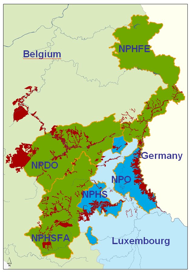 |
| Figure 2. Map of the study area: red surfaces represent Natura 2000 areas. (click for larger version) |
The main objectives of this cross-border project were to:
- Assess the quality of otter habitats and threats (water quality, refuges, contaminants, potential risks like traffic road accidents, etc),
- Improve otter habitats with management measures such as the installation of fences along riverbanks, drinking troughs and mitigation measures under bridges, etc,
- Protect the last otters in Belgium and in Luxembourg,
- Facilitate the otter migration and try to restore corridors between the two main western European otter populations
METHODOLOGIES
To implement mitigation measures on the area covered (Fig. 2), some prior investigations were carried out to assess existing habitats for the survival of otters and define areas of priority where actions should be focused in order to enhance the quality of these habitats. This process followed a recognized and adapted methodology. In the same way, a European and standardized survey method was used to follow the evolution of the otter population in Luxembourg and in the South-east of Belgium.
The food quality (especially fish that represent 80 % of the otter’s food sources) was also assessed.
These three methodologies are described hereafter:
Assessment of otter habitats and black spots
The methodology used (Schmidt et al., 2008) was adapted from Libois (2000) and consists of noting and assessing all the structures (woodheap, brambles bush and willows clump, etc) on both sides of the riverbanks. A value is established for the different structures, according to the proximity of the river (5 or 10 metres), the presence of potential disturbances (e.g. a road or a camping site), the presence of remarkable features of the structure (e.g. burrows, cavities in trees,), which allows otters to live there in quiet conditions during the day at least. All these data were encoded in a Geodata base with point feature classes. This database is connected to a Geographic Information System (GIS, Arcmap) to elaborate maps and statistical models.
The assessment of the habitat quality was based on the number of remarkable structures present in an area of 500 m2. The habitat potentiality was defined upon the possibility for one otter to find a quiet place during the day.
On the basis of the numbers of structures per square of 500 m side length, priorities of habitat restoration by river sector were defined by considering at least three successive squares (Fig. 3).
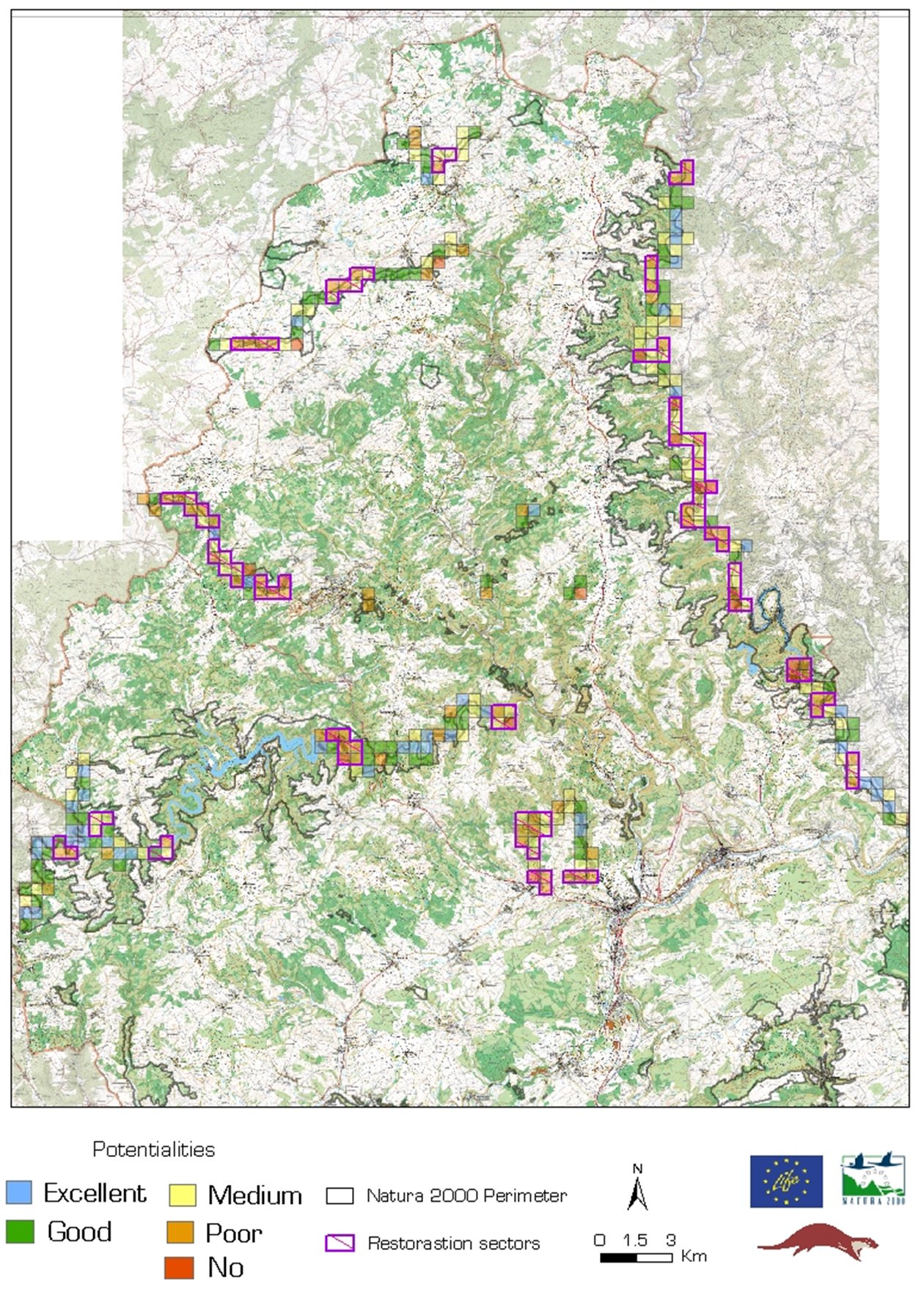 |
| Figure 3. An example of habitat assessment for the otter in the North of Luxembourg (restoration priority areas are in pink). (click for larger version) |
The selection of the priority areas enables an adequate management of the different mitigation measures proposed. Furthermore, this databank integrated the data concerning black spots like coniferous forests, water access for cattle, sewage effluent, erosion of riverbanks and dangerous bridges.
Standardised survey of the European Otter populations
To document the evolution of the otters’ population in the study area on the basis of otter tracks and spraints mapping, we used the Information System for Otter Surveys (ISOS) developed by Reuther et al. in 2000 as a standardized and European methodology. It utilizes a UTM (United Transversal Mercator) grid with squares of 10x10 km (Fig. 4) divided in four squares of 5x5 km where one survey is done between September and April, every three years. This survey has a total stretch of 600 m along one side of the riverbank.
 |
| Figure 4. Application of the ISOS methodology to the study area (squares of 10x10 km). (click for larger version) |
The simplified ISOS methodology integrating 16 sites in the square of 10x10 km was also used to intensify the investigation. In this case, the survey was made yearly around each spot check.
Assessment of the evolution of contaminants in fish
To assess the contamination in fish, a study of the content of polychlorinated biphenyls (PCB), heavy metals (cadmium, chromium, mercury and lead) and pesticides (DDD, DDT, DDE) was carried out in 1994 on four species of fish: the barbel (Barbus barbus), the chub (Squalius cephalus), the eel (Anguilla anguilla) and the stone loach (Barbatula barbatula) in 20 sites and in 2007 with the same species and parameters essentially to compare the evolution of these contaminants.
RESULTS
Globally, the action’s realisations generally surpassed the objectives defined at the beginning of the project (Table 1).
The percentage of realization was often above 100 % (between 100 % and 445 %) except for the planting of hedges (82 %) and the restoration of spawning grounds (87 %).
The lack of plantation of hedges is principally due to the low acceptance by farmers of this kind of management in farming. The restoration of spawning ground and backwaters needs a lot of time for the feasibility study, for convincing the owners and for obtaining all the authorizations to carry out the management. The possibilities of the project were limited in this respect. Hereafter, the detailed results of the project are presented.
Water quality and fish contaminants
Between 1995 and 2007, in many cases, the level of PCBs was clearly decreasing compared to the study carried out in 1995 (Hugla et al., 1998). However, this decrease is very variable from site to site and species to species (stable to 10 times more).
To assess the impact on the otter, the level of contamination of PCBs in otter livers potentially feeding on these fish was predicted with a mathematical model. The conclusion was that the current situation could affect the reestablishment of the otter population in this area (Boscher et al., 2010).
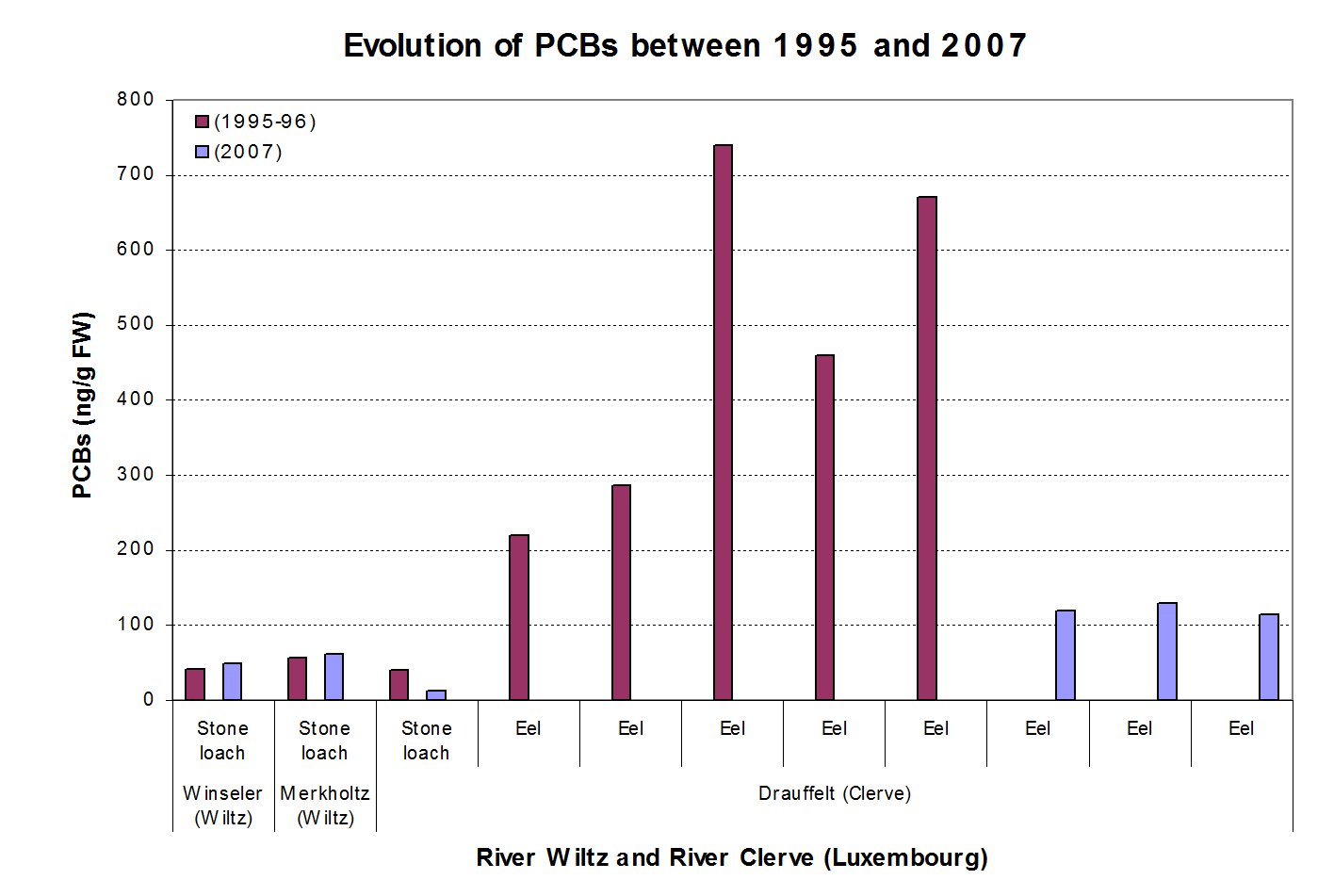 |
| Figure 5. Level of PCBs in eel and stone loach in the Wiltz and the Clerve Rivers. Comparison between 1995-1996 and 2007 (click for larger version) |
Cadmium and mercury concentrations in fish were found to be above the recommended value for the otter in some rivers of Luxembourg (the Our, the Wiltz and the Clerve Rivers) (Boscher et al., 2010) and Belgium (the Our and the Two Ourthes Rivers) (Boscher et al., 2008). The evolution of the pesticides concentrations in fish is quite the same as for PCBs: a decrease of about 10 times the concentration from 1994 and in some cases under the detection level (Boscher et al., 2008).
These results were used to achieve an otter action programme plan to enhance the water quality (a sewage treatment plan) and to try to locate and eliminate micropollutant sources (PCBs and heavy metals).
Protection of otter habitats and potential resting places
The first objective of the project was to protect the capacity of resting places and favourable ecosystems for the otter, such as meadows of wetlands and alder river forests. To achieve this objective, about 105 ha of land were acquired for the creation of natural reserves (the initial objective was 57 ha). Moreover, agreements with private owners and associations were initiated to create 31 otter havens (Fig 6).
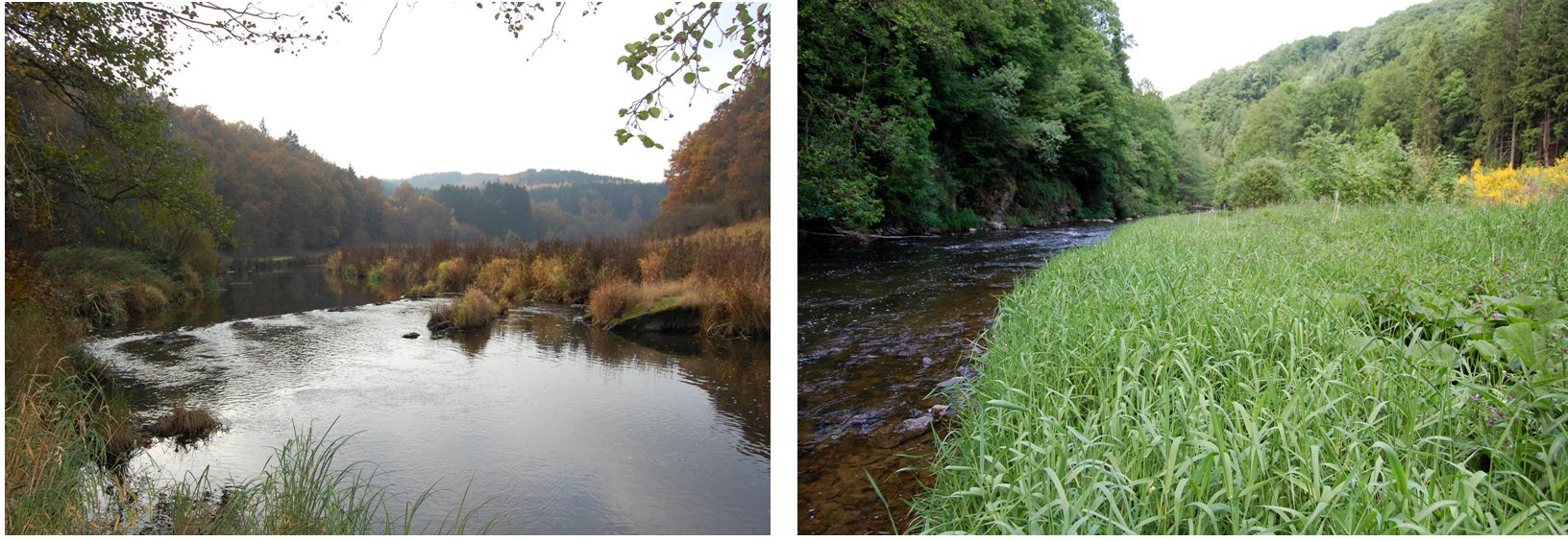 |
| Figure 6. Examples of otter havens along the Upper Sûre and Our Rivers (click for larger version) |
Otter havens consisted of 30 years long agreements signed with private owners and nature conservation associations in order to protect habitats of the otter, avoid human disturbance (noise, accidental trapping, dogs wandering, etc) and maintain riverbanks in natural conditions.
Restoration of humid floodplains to enhance quality of the otter habitat
The presence of spruce plantations in floodplains reduces the possibility of natural habitats favourable for the otter, like bramble bushes and reed-beds. The restoration of floodplains was carried out by an earlier deforestation of about 150 ha of spruce stands in the study area (Fig. 7). With financial compensation established in an agreement signed on a voluntary basis for 30 years, private owners accepted to do an early cutting and to replant only softwoods like alders, willows, ashes, maples.
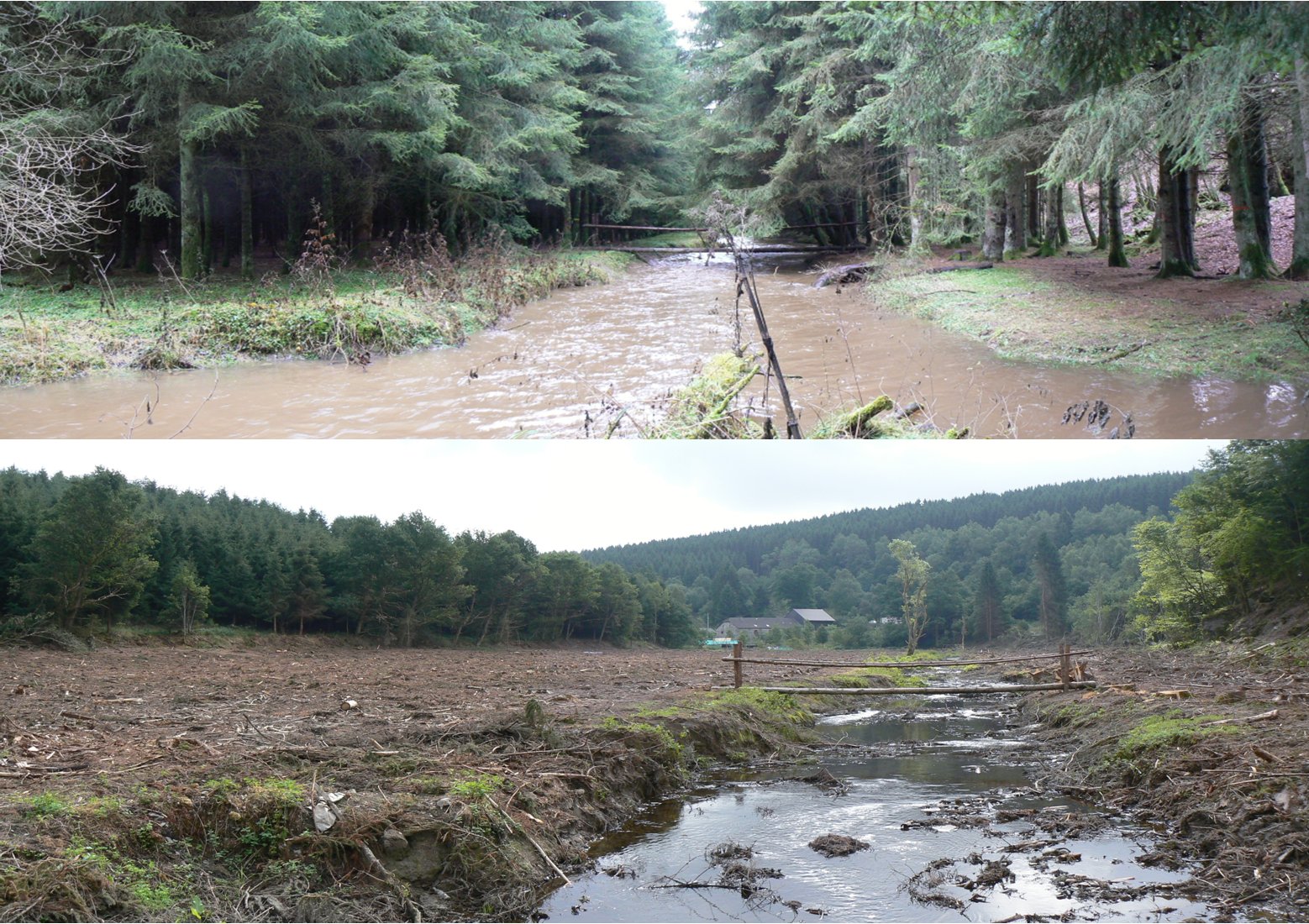 |
| Figure 7. Example of an early cutting of spruce plantations along the Ourthe in an area of 8 ha (situation before and after) (click for larger version) |
Some sites were bought and used as nature reserves with a natural reforestation, extensive meadows or a combination of both. Their management was assigned to the Walloon Administration (Nature and Forestry Department) in Belgium respectively to the Hëllef fir d´Natur foundation in Luxembourg.
Protection and management of the riverbanks
Livestock grazing can damage riverbanks and have a negative impact on the water quality. To solve this problem, the free installation of fences, drinking troughs and footbridges was offered to farmers (Fig. 8). In exchange, owners have to maintain the material and control it once a year. These conditions are described in a 5-year long agreement. Furthermore, the planting of trees on the riverbanks was proposed to avoid soil erosion.
The result of this action consisted in: the installation of 61 km of fences, 263 drinking troughs and the plantation of 23 km of young trees (alders and willows mostly) on the riverbanks, on a width of about 3 to 5 m.
Enhancement and diversification of the food resources
One of the most important targets of this project was to restore the natural productivity of the watercourses in the study area. To this end, 7 spawning grounds were restored (Fig. 9), 21 obstacles for fish migration were removed (Fig. 10) and 178 ponds were dug (Fig. 11).
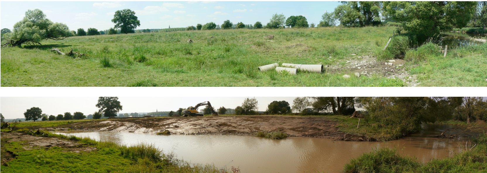
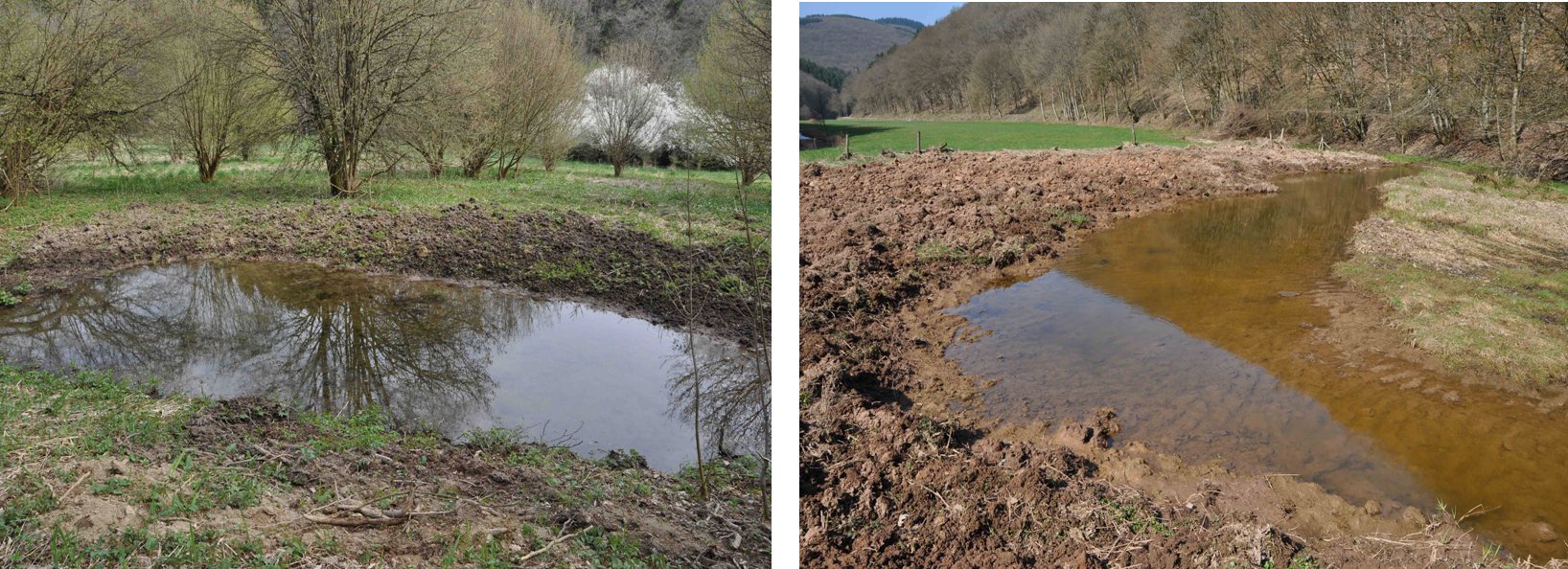
These kinds of management measures are likely to enhance (1) the fish mobility, which is necessary for the reproduction and the genetic mixing of fish populations, (2) the spring spawning possibilities for the pike and white fish in backwaters, and (3) the number of favourable sites for amphibian reproduction.
Improvement of the living conditions for the otter
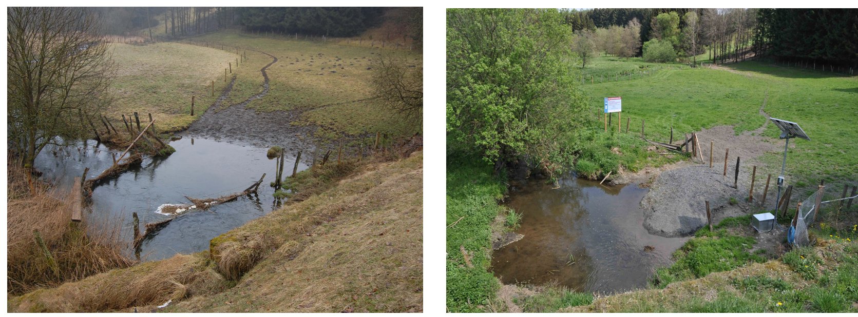
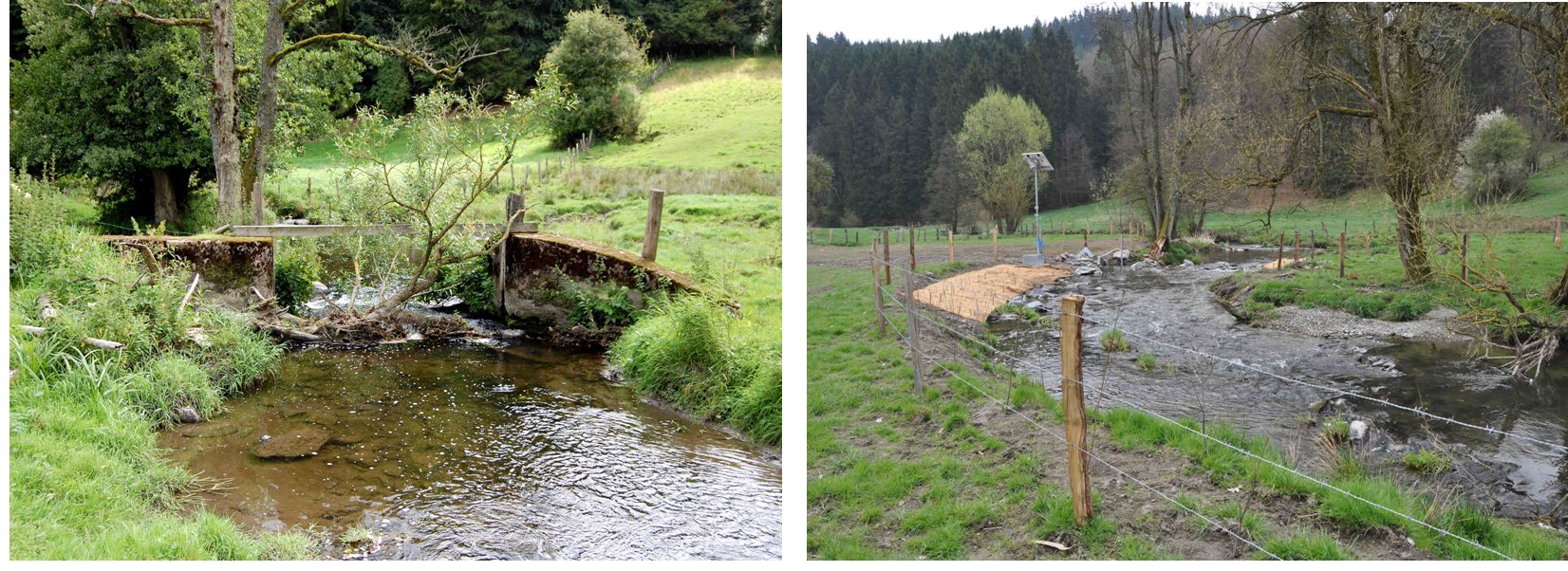
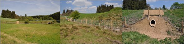
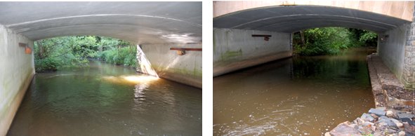
In most European countries, the highest mortality rate for the otter is due to road accidents (from 40 to 80 %) (Etienne, 2005). To avoid or minimize these risks, an assessment of the danger at 245 bridges was made in 2006 and 2007. Seventy of them were considered as dangerous. Considering the intensity of the road traffic, a rigorous selection of the most dangerous bridges was done. Nine of these bridges were equipped with passages and fences to direct the animals under the bridge or in the culvert (Figs 12 and 13).
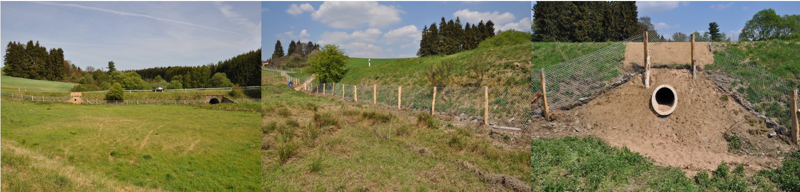
To enhance the availability of resting places and reproduction burrows, 9 artificial otter holts were installed in otter havens (Fig. 14).
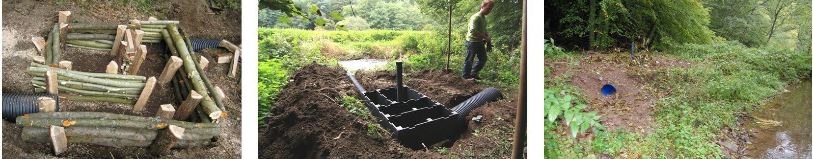 |
| Figure 14. Examples of otter holts made of wood or in recycled plastic. On the right, result of the setting along the Wark River (click for larger version) |
These holts can be used by other species such as the polecat. The durability of the structure is about 20 years for wood and 100 years for plastic.
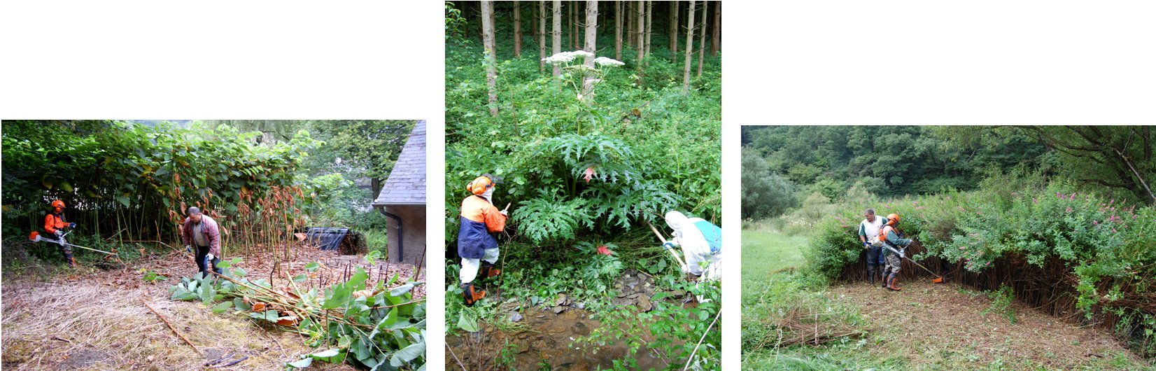
Moreover, improving the otter’s habitats means preserving the indigenous vegetation like bramble stands and prickly bushes, and clumps of willows that are used by the otter as shelter during the day. To avoid the degradation of these riverside structures by invading plants like the giant hogweed (Heracleum mantegazzianum), the Japanese and the Sakhalin knotweeds (Fallopia japonica) (Fallopia sakhalinensis), different species of spireas (Spirea spp.), and the Himalayan balsam (Impatiens glandulifera), about 189 ha of invasive plants were managed during 5 ½ years. These measures (pulling up of hogweed roots, mowing of balsams and spireas, etc) (Fig. 15) were made principally along the Two Ourthes Rivers in Belgium and on the Our and the Upper Sûre Rivers in Luxembourg with the collaboration of a lot of partners (administrations, volunteers, municipalities. etc).
 |
| Figure 15. Examples of otter holts made of wood or in recycled plastic. On the right, result of the setting along the Wark River (click for larger version) |
The results of these treatments were divergent, from about 70 % of eradication with the Himalayan balsam and the spireas to more than 90 % with the Giant hogweed. There were real difficulties with the two knotweeds (two times a year mowing and then covering with a tilth) because of the dense root system of this plant.
Public awareness and education
At the start of the project, a call was made for volunteers to create a network of otter track observers. About 316 people were trained to recognize footprints and excrement of mammals living along the watercourses. About 120 volunteers were involved in the observers network at the beginning in 2008. Each member of the network was assigned to cover a square of the ISOS method in 2008 and in 2010. Otter tracking “Weekends” were also organized for training and exchanging information in the volunteer group. Furthermore, a mammal track’s guide was published in French and German languages in order to be used in the field.
Despite the fact that neither tracks, nor otter spraints have been found in the study area, more than 700 data on mammal presence information were collected and encoded in a database of the Walloon Region and Luxembourg. Three photo traps placed under bridges managed to pick up some photos of different mammals but still no otters (Fig. 16).
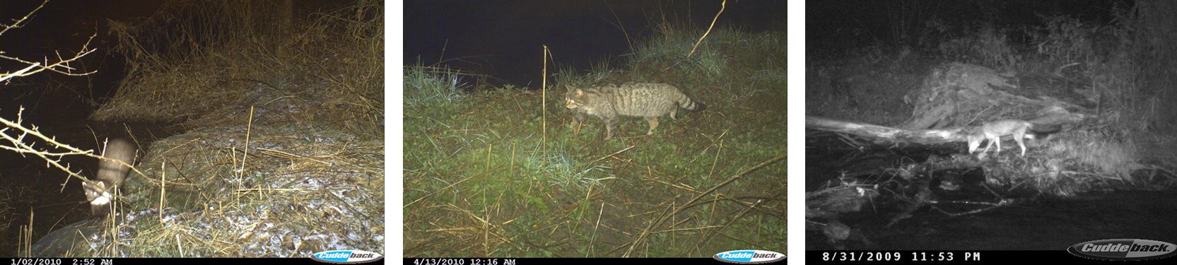 |
| Figure 16. During the night, pictures of a stone marten, a wild cat and a fox (click for larger version) |
To reach the objective of awareness of the general public two educational tools were developed and used: an educational file “On the tracks of the otter” and a travelling and interactive exhibition (Fig. 17) produced with the help of teachers and educational specialists. More than 4200 people and 2800 pupils participated in information and educational activities between 2005 and 2010.
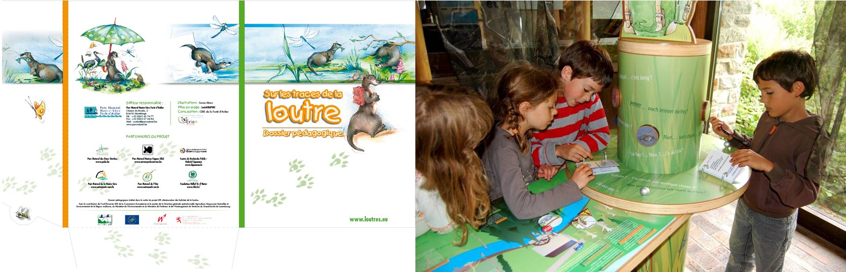 |
| Figure 17. Illustrations of the educational file and the travelling exhibition (click for larger version) |
DISCUSSION AND CONCLUSION
Despite the fact that the project objectives were reached far beyond the initial planning, a lot of work remains if the black spots assessment and the percentages of realization are compared (Table 2). These percentages vary from 2.3 to 76.5 %, indicating that there are high deviations between the results of actions in the different perimeters.
| Table 2. Balance sheet of the managed black spots in the different catchment perimeters in the study area of the project. (click for full size version) |
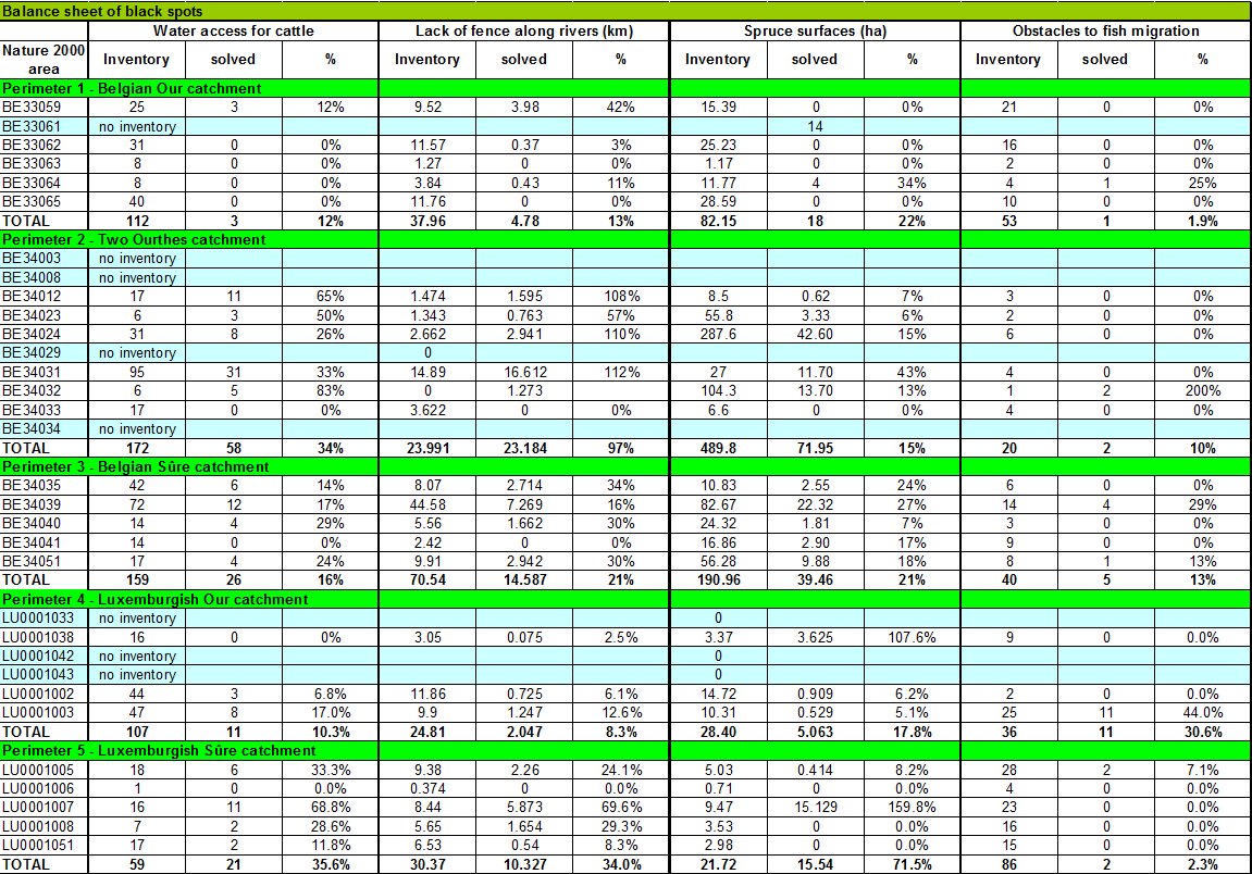 |
This variation is principally due to the acceptance of the project and the sensitisation of the people concerned (farmers, private owners,), but also to the large amounts of black spots assessed at the beginning of the project in the different perimeters.
If most of the risks of road accidents along bridges from the principal watercourses have been reduced, the connections studies (Degen, 2008; Tock, 2008) have emphasised that passages between catchments remain dangerous for the otter in case of migration. Thus, for example, about 10 bridges that need to be managed were identified in order to avoid road accidents in the Sûre catchments.
Different authors (Kruuk, 2006; Reuther, 2004) mentioned risks that could affect the conservation of the Eurasian otter: problem of availability of water, of food and habitat, pollution burden, difficulties of exchange and expansion, density of road traffic, etc.
In the study area, there is in general enough water, habitat and food supply. However, problems due to road traffic in the connection areas and contamination by pollutants (PCBs, heavy metals) remain potential risks for the otter and are the most important to be solved.
The possibilities of recolonization are noticeable but have to be improved with other connections like the Semois River, the Low Sûre River and the Moselle River. In consequence, a transnational otter action plan has been set up for the next 10 years in order to manage these connections (Plan loutre, 2011-2021).
Some actions like the restoration of floodplains by the earlier deforestation of spruce stands and the management of invasive plants seem to have a more indirect and long terme impact on the otter conservation and a more direct impact on biodiversity and diversity of habitat of the otter.
An important objective for the future is to maintain the different structures and tools generated by the project. This includes the activities of the observers’ network, the monitoring of otter passages and artificial holts, the application of the different agreements signed with farmers and private owners, and the use of the interactive and educational exhibition. This kind of activity enacted by the European Commission is essential to follow the return of the otter and guarantee the durability of the measures of the LIFE project after its official term (After LIFE project).
About the different actions made, it is also of consequence to know which are relevant and which are secondary. It is for example useful to see if artificial otter holts are well installed and used. In this point of view, artificial holts have to be located where there is little natural cover and minimal disturbance by humans and particularly by dogs (Sussex Otters and Rivers project, 2008). The future monitoring has to confirm if these managements were useful and optimal or not.
What are the main conclusions and lessons to be learned from this LIFE-Nature project?
To reach the predefined objectives, it is really important to begin early the sensitization of the population, to convince farmers, private owners and administrations to participate actively in the project. Quick and concrete examples of achievements are important to immediately give a positive image of the project in order to involve other farmers and private owners. Motivated partners who are likely to push forward the project are essential. With 7 partners, 20 different actions and a budget of 3,891 million Euros, it is necessary to have a good coordination, to be flexible and adapt the objectives and budgets of the different actions depending on the assessments and new targets that could be defined during the process. Thus, the European Commission accepted three codicils of the project to adapt and reach the modified objectives per action.
Fourteen people have worked together on the project with different expertise. However, some particular aspects of the project (the building of otter passages, the concept of the travelling exhibition, the cutting of spruces, the writing of agreements, etc) necessitate different skills, among others technical and jurist advice. The cross border particularities of this kind of project are relevant but not always easy to manage. To assure the achievement of the different tasks, a coordination structure was based on a cross border technical committee, two national follow up committees and one cross border follow up committee, which was composed of different administrations, ministries and partners of the project.
To avoid overlap of actions between projects, it is helpful to have exchanges with other LIFE or Interreg projects by comparing methodologies and aims as well as to find potential synergies.
Otter conservation and management without a real population is a challenge for the future and the return of this species in our countries.
Acknowledgements - First of all, we would like to thank the European Commission, the Ministry of Sustainable Development and Infrastructures (MDDI), the Ministry of Home Affaires and the Greater Region (MIGR) of Luxembourg and the Walloon Region (Agriculture, Natural Resources and Environment Operational General Department) for the financial support in the framework of the LIFE-Nature project (LIFE05 NAT/B/000085). We also thank Dr R. Libois and V. Schockert for their scientific support on otter habitat methodology and Prof. J.P. Thomé (University of Liège, B) for PCB, heavy metal and pesticide analyses in fish from the Walloon Region, the Aktion Fischotterschutz e. V. (D) for their scientific help on otter ecology training and for the nice photos we were allowed to take and use, Alterra (N) for DNA analyses of spraints. The collaboration of the different administrations and enterprises that worked with us in the field to reach the objectives of the different actions of the project is also greatly acknowledged. Finally, our gratitude goes to the farmers, private owners, teachers and volunteers who contributed to the success of this LIFE project.
In memory of Jim Conroy who supported us during the project.
REFERENCES
After-LIFE “Conservation Plan” Wallonie et Luxembourg (2011). Centre de Recherche Public – Gabriel Lippmann, Belvaux, Luxembourg, Parc naturel Haute-Sûre Forêt d‘Anlier, Martelange, Belgique.
Boscher, A., Dohet, A., Ghyselinck, H., Leclercq, Ch., Louvet M., Plattes S., Schmidt G., Thomé J.P. (2008). Centre de Recherche Public – Gabriel Lippmann, Luxembourg.
Boscher, A., Gobert, S., Guignard C., Ziebel, J., L’Hoste, L., Gutleb, A.C., Cauchie, H.M., Hoffmann, L., Schmidt, G. (2010). Chemical contaminants in fish species from rivers in the North of Luxembourg: Potential impact on the Eurasian otter (Lutra lutra). Chemosphere, 78: 785-792.
Bouchardy, C. (2001). La loutre d’Europe, histoire d’une sauvegarde. Catiche Production, Libris, Paris.
Degen, A. (2008). Aménagements de passages naturels entre bassins versants contigus (actions C3 du projet LIFE loutre). Etude réalisée dans le cadre d’un stage en Maîtrise de Biologie des organismes et Ecologie (MBOE) – UCL, Louvain-la-Neuve, Belgique.
Etienne, P. (2005). La loutre d’Europe, description, répartition, habitat, mœurs, observation… Les sentiers du naturaliste. Delachaux et Niestlé, Paris.
Groupe Loutre luxembourgeois (1994). La loutre au Luxembourg et dans les pays limitrophes, Der Fischotter in Luxemburg und in den Nachbarländern. Fondation Oeko-Fonds et Musée national d’histoire naturelle, Luxembourg.
Groupe Loutre Luxembourg (1997). Evaluation de la qualité des cours d’eau au Luxembourg en tant qu’habitat pour la loutre. Travaux scientifiques du Musée national d’histoire naturelle. Luxembourg, 26: 3-125.
Hugla, J.L., Dohet, A., Thys, I., Hoffmann, L., Thomé, J.P. (1998). Contamination par les PCBs et les pesticides organochlorés des poissons du Grand-Duché de Luxembourg : incidence possible sur les populations de loutre (Lutra lutra L.).Annales de Limnologie, 34: 201–209.
Kruuk, H. (2006). Otters: ecology, behaviour and conservation. Department of Zoology, Aberdeen, Scotland. Oxford University Press.
Leonards, P.E.G., Smit, M.D., De Jong, A.E.J.J., van Hattum, B. (1994). Evaluation of dose-response relationship for the effects of PCBs on the reproduction in mink (Mustela vison). Institute for Environmental Studies, Amsterdam.
Libois, R.M. (2000). Evaluation de l’habitat en fonction des impératifs de protection de la loutre (Lutra lutra) dans le bassin de l’Our (Parc Naturel Hautes Fagnes-Eifel). Université de Liège, Ministère de la Région Wallonne.
Plan loutre 2011-2021 en Wallonie et au Grand-Duché de Luxembourg, rédigé dans le cadre du projet LIFE “Restauration des Habitats de la Loutre”, LIFE 05/NAT/B/000085, 2011. Parc naturel des 2 Ourthes, Parc naturel Haute-Sûre Forêt d’Anlier, Centre de Recherche Public – Gabriel Lippmann, Belvaux, Luxembourg.
Reuther, C., Dolch, D., Green, R., Jahrl, J., Jefferies, D., Krekemeyer, A., Kucerova, M., Madsen, A.B., Romanowski, J., Roche, K., Ruiz-Olmo J., Teubner, J., Trindade, A. (2000). Surveying and Monitoring Distribution and Population Trends of the Eurasian Otter (Lutra lutra): Guidelines and Evaluation of the Standard Method for Surveys as recommended by the European Section of the IUCN/SSC Otter Specialist Group. Arbeitsberichte der Aktion Fischotterschutz e.V., Hankensbüttel. Habitat, 12.
Reuther, C., Kölsch, O., Jansen, W. (2004). On the Way Towards an Otter Habitat Network Europe (OHNE). Method and Results of an Area Assessment on the European and German Level. Publishing company GN-Gruppe Naturschutz GmbH, D-29386 Hankensbüttel. Habitat, 15.
Schmidt, G., L’Hoste, L., Dohet, A., Boscher, A., Cauchie H-M., Hoffmann, L. (2008). Riverbank assessment and management for the Eurasian otter in the North of Luxembourg. Animal Biology, 58: 473-490.
Sussex Otters and Rivers Project (2008). Building a Plastic Recycled Otter holt. Part of Water for Wildlife UK. Environment Agency.
Tock, P. (2008). Verbesserung von natürlichen Verbindungen zwischen benachbarten Gewässereinzugsgebieten. Berufspraktikum. Institut für Landschaftsökologie. Institut für Landschaftsökologie (ILÖK), Münster, Centre de Recherche Public – Gabriel Lippmann. Belvaux, Luxembourg.
Résumé : La Restauration des Habitats de la Loutre au Grand-Duché de Luxembourg et en Belgique: 5 Années d’Actions en Faveur de la Loutre d’Europe (Lutra lutra)
En 2005, 7 partenaires dont 5 parcs naturels (Haute-Sûre, Haute-Sûre et Forêt d'Anlier, Our, Hautes Fagnes-Eifel et deux Ourthes), la fondation Hëllef fir d’Natur et le Centre de Recherche Public – Gabriel Lippmann ont proposé un projet LIFE-Nature pour préserver et restaurer les habitats des dernières loutres au Luxembourg et en Belgique. Cet ambitieux projet transfrontalier visait à améliorer les habitats de la loutre et à tenter de restaurer les couloirs de migration situés entre les deux principales populations de loutre de France et d’Allemagne en vue de faciliter la migration des espèces et contribuer à rétablir des populations de loutre stables dans nos régions. Pour atteindre ces objectifs, les actions suivantes ont été définies et mises en oeuvre : (1) l’amélioration de la productivité piscicole (par la restauration de 6 frayères et la suppression de 21 obstacles à la migration des poissons), (2) la diminution de l’impact lié à la présence du bétail le long des cours d’eau (par l’installation de 262 abreuvoirs, la pose de 61 km de clôture et 23 passerelles), (3) la promotion d’essences arbustives indigènes par la coupe précoce des forêts résineuses situées en zones inondables (150 ha), (4) l’exploitation du bois tout en respectant les cours d'eau, (5) l’aménagement de connexions entre bassins versants par la plantation des berges à l’aide d’arbres et arbustes indigènes (23 km) et le creusement de mares (178), (6) l’installation de passages sécurisés sous les ponts pour loutre mais également pour les petits mammifères (la construction de 9 passages), (7) la création de réserves naturelles (105 ha) et de havres de paix pour la loutre (31) et finalement (8) la gestion des plantes invasives (189 ha) dans les zones Natura 2000. La sensibilisation du public fut également un élément important du projet avec la conception et la réalisation d'une exposition itinérante et d'un dossier éducatif. Par ailleurs, un réseau d’observateurs loutre, composé de volontaires, a été mis en place afin d’essayer de trouver des traces de pas et des épreintes dans la zone d'étude entre 2007 et 2010.
Revenez au dessus
Resumen: Restauración de Hábitats de Nutria en Luxemburgo y Bélgica: Acciones Durante 5 Años en Favor de la Nutria Eurasiática (Lutra lutra)
En 2005, 7 instituciones (5 Parques Naturales -Haute-Sûre, Haute-Sûre Forêt d’Anlier, Our, Hautes Fagnes-Eifel, Two Ourthes), la Fundación Hëllef fir d´Natur y el Centre de Recherche Public (Gabriel Lippmann)), se asociaron para proponer un Proyecto LIFE-Nature para preservar y restaurar los hábitats de las últimas nutrias en Luxemburgo y Bélgica. Este amplio proyecto trans-fronterizo está dirigido a mejorar los hábitats de las nutrias, y tratar de construir ó reconstruir corredores entre las dos importantes poblaciones de nutrias localizadas en Francia y Alemania, para facilitar la migración de la especie y contribuir a re-establecer poblaciones estables de nutria en nuestros países. Para alcanzar estos objetivos, fueron definidas las siguientes acciones: (1) mejora de la productividad natural de peces (mediante la restauración de 6 áreas de desove y la remoción de 21 obstáculos a la migración de peces), (2) disminución de los impactos relacionados con la presencia de ganado vacuno a lo largo de los ríos (instalación de 262 bebederos, 61 km de alambrados, 23 puentes peatonales), (3) promoción de especies nativas de árboles, mediante la corta temprana de bosques de abeto en las llanuras de inundación (150 ha), (4) explotación de los bosques respetando al mismo tiempo los cursos de agua, (5) estimulación de las conexiones entre las cuencas, plantando los bancos ribereños con árboles y arbustos nativos (23 km) y excavando lagunitas (178), (6) instalación de pasajes seguros para la nutria -pero también para pequeños mamíferos-, por debajo de los puentes (manejo de 9 pasajes de nutria), (7) creación de reservas naturales (105 ha) y refugios de nutrias (31) y finalmente (8) manejo de plantas invasoras (189 ha) en las áreas Natura 2000. La concienciación pública también fue un elemento importante del proyecto, con la producción de una exhibición itinerante y un portafolio educativo. Más aún, se estableció una red de observadores de nutria, compuesta por voluntarios, para tratar de encontrar huellas y marcas en el área de estudio entre 2007 y 2010.
Vuelva a la tapa